
The forecast for both today and tomorrow said sunny with no rain. Thank goodness. We have postponed exploring the island because it has been raining so hard every day. So, this morning we headed to shore early. It was drizzling lightly and quite gray, so we were dubious about the forecast’s accuracy.
We found a car rental place and rented a 4 wheel drive Jeep. The plan was to go up to Washington-Slagbaai National Park. They only allow vehicles with high wheel clearance in the park, and 4 wheel drive is recommended in the wet season. The lady who rented us the car explained that there were two roads through the park, the long road along the coast and the short road inland, and said the long road is much more beautiful than the short road. There are supposed to be some nice spots to snorkel/dive off both roads. By the time the car paperwork was completed, the drizzle had burned off and it was sunny and gorgeous out.
We drove east a couple of blocks and quickly found the road that went north through the center of the island. We stopped at a roadside café for a quick breakfast. Our choices were either chicken or beef pastechis. We got one of each. They look like very large empanadas, but they are made with a more delicate flour, though not quite as delicate as a traditional puff pastry. They are stuffed with the respective seasoned meats and deep fried. The seasoning they use is absolutely delicious.
Back in the car, we started up the highway. At first it was lined with mostly warehouse looking buildings, with many empty lots between buildings. When we say empty, we don’t mean plain dirt. The lots are loaded with green foliage. After a few blocks, the street became residential, with a house here and there between empty lots. Most of the houses are small bungalow style in bright colors. After a few more blocks, the road became mostly undeveloped land, with a small structure here and there. Out in the middle of nowhere we passed a land sailing track. That caught our eye. It looks like fun.
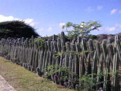
It is incredibly green and the foliage is dense. Part of us wasn’t surprised by the greenness, given so much rain, and part of us was surprised since this is supposed to be a dry island. In looking closer at the foliage, it looks like most of the plants are dry weather plants. There are a lot of cactus, in several different varieties. Some of the cactus plants are absolutely enormous. In and amongst the cactus are many varieties of trees, though we didn’t recognize any specifically. We did see a handful of small agricultural plots. It looked like mostly corn, which we know is one of the few foods grown on this island. Something we found interesting was that the occasional house and plot of land was usually surrounded by a fence made of cactus.
The northern part of the island is hillier than the south, and we saw some striking looking hill and rock formations along the drive. After about 15 minutes, we made it to the town of Rincon, which is the original Spaniard settlement on the island. Rincon looks like a miniature version of Kralendijk. It is a very small town, and outside of town it quickly goes back to being largely undeveloped land.
From town, we followed the signs northeast up to the park. The paved road ends at the entrance, on the east side of the island. Outside the entrance there are pretty views of the rugged landscape framed by the ocean beyond. Just inside the entrance is a congregation of small maize colored buildings that make up the visitor’s center. There bones of a whale are on exhibit in a prominent location near the ticket booth. It was a Bryde’s Whale that was killed by a cruise ship in 2000 and “was deposited” in the south of the island. It was a juvenile that was 13 meters long and weighed 11 metric tons. It is hard to believe something so enormous was only a juvenile!
After checking out the whale, Eric got in line for tickets. He found out that the long road is closed today because the road is too muddy from all the recent rain, but the short road was open. We decided to skip the park for today and explore the southern part of the island, instead. Our logic was that if it doesn’t rain today, maybe the long road will dry out and we can take it tomorrow.
We turned around and headed back to Rincon. From Rincon, we took a road west to the coast. The coastal road turned out to be one way only, so we couldn’t go south. We found a dirt road that looked like it paralleled the main road. We know further south the road is two ways, and figured the two roads would eventually connect. We were mistaken. The dirt road was to a tower of some sort. We backtracked to the paved road and drove north for a little bit, enjoying the pretty view. Then we headed back inland to Rincon and took the inland road back south.
On a side note, there are a lot, and we mean a lot, of lizards running around on the roads in the north. There are several species, including iguanas. One species is particularly eye catching it has a bright blue tail! We also saw a donkey hanging out of the side of the road, and we got the impression it is wild.
When we got back to Kralendijk, we took a road southeast. The buildings were a mix of commercial and residential, but quickly thinned out and it became mostly vacant land. The landscape is totally flat down here, barely above sea level. The plants look to be pretty much the same as in the north, but the plant life is sparse compared to the north. There are significantly less trees. Clearly the ground is less fertile here.
After not too long, we came to wetlands. We saw several flamingos in the water, but most were way out in the distance and looked like nothing more than pink dots on the horizon. We did get a good look at one flamingo hanging out closer to the road, but even he was pretty far away. It looks like the water is incredibly shallow it seemed to barely cover the flamingo’s feet.
The wetlands eventually turned into Luc Bay, which is famous for windsurfing. The bay itself is quite large, but very shallow, and is completely protected from the open ocean by a reef and a field of mangroves. The trade winds always blow here, and the combination makes for ideal windsurfing conditions. It is supposedly the best place in the world to learn to windsurf. Luc Bay hosts an assortment of wildlife species. It is also an important breeding ground for two endangered species: conch (which we hadn’t realized is endangered) and green turtles. To add to random trivia, it is believed the original Amerindian settlers (the hunter-gatherers) originally settled around Luc Bay.
We drove over to the windsurf shop. Next door to it is a beach bar. The bay was crowded with windsurfers gracefully gliding along the water and the beach was full of spectators baking in the sun. We went into the shop and made an appointment for a lesson at 1600, then hopped back in the car to continue our tour of the south end of Bonaire.
To be continued”¦
Conch is endangered? Just that particular kind? I swear I’ve seen people eating conch recently on some sort of food show.