
Today we explored the northernmost regions of the island. The first place we went to was the beach at Deep Bay. You may remember that we attempted to anchor in Deep Bay when we first arrived from Barbuda. We remembered it was beautiful and thought it would be a nice beach to go back to. Getting to Deep Bay was a little hairy. We went to St. John’s, then headed west. In general, the roads in Antigua aren’t well maintained, but the road west was worse than usual. Near the bay, we turned off on a small side road that was nothing but a giant pothole. We think we scraped the heck out of the bottom, along with ruining the alignment and suspension of the car on this stretch of road. Anyway, the road parallels a salt pond, which is a long, narrow and shallow body of water fed by a small opening to the ocean. The road came to an end at the rocky shoreline where the salt pond meets the open ocean.
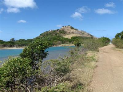
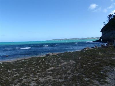
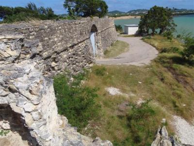
We stopped to observe the waves. The seas were tumultuous and the waves were crashing violently against the shoreline. We are so glad we aren’t at sea right now! We crossed the small foot bridge over to the west side of the salt pond. The steps on either side of the foot bridge were desperately in need of serious maintenance and they were actually kind of scary. The bridge itself looked very sturdy. The west side of the salt pond is a slender peninsula that separates the salt pond from Deep Bay. At the very end of the peninsula, above the ocean, is a big hill. On top of that hill is the remains of Fort Barrington, originally built in the mid-1600’s. The first photo shows the road on the left, the salt pond in the middle, and to the left you can see the strip of land and hill with Ft. Barrington remains. The second photo is of the shoreline from where the road ends. If you look carefully, you can see the ocean is full of whitecaps.
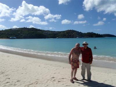
We followed a little foot path from the bridge, unsure if it would take us up the hill to the ruins or if it would take us to the beach. It took us through thick vegetation and let out at the beach. We know we say this of every beach, but this is definitely the most beautiful one we have been to yet. The water is such a pretty shade of blue, the sand is gleaming white, and there are beautiful shade trees all along the beach.
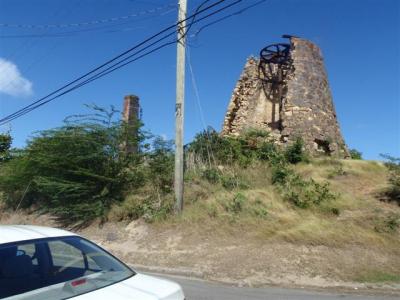
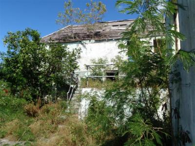
Once we got to the point where we felt like we had gotten enough sun, we headed out. We debated going up to see the ruins, but honestly, no one really felt like doing the hike. We went back to St. John’s. On the way, we got a good shot of an old sugar wind mill tower. They used the wind power to process the sugar cane. There are 109 of these sugar mills still standing, and we have seen many as we have driven around. We believe two are now a museum, and most of the rest have been turned into other things, like restaurants or shops, but we do see a few that are abandoned, like the one pictured here.
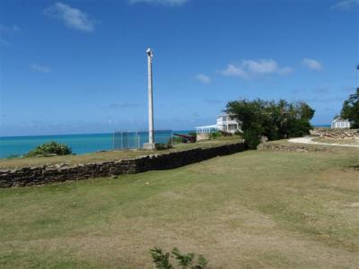
We drove back to St. John’s and this time headed to the ruins of Fort James, located at the entrance to St. John’s Harbor, which is northwest of downtown St. John’s. To get there we followed a winding coastal road. At first it was residential, then became a commercial port area, then eventually became a nice looking park/beach area with quite a few people relaxing in the park. The fort is at the end of the park, at the very tip of land where the ocean meets the bay. It was originally built in 1675. The exterior walls are intact and we were able to drive in through the main gate. You can almost envision people riding horses and carriages through this gate in the old days. The grass was nicely mowed. From the entrance side of the fort are great views of the bay, and from the back side are great views of the ocean. To the right is a restaurant housed in the old Officer’s Quarters, which is a pretty building. Near the entrance is a gun powder magazine, and it looks just like the one in Ft. Berkley. To the left is the interior walls, behind which the heart of the fort lies. A few canons dot the edges of the grassy fields. Once upon a time there were probably more buildings and facilities on this grassy plain, but they were gone now. Here is a shot of the exterior walls and of the plain and officer’s quarters.
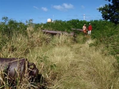
We parked and went through the opening in the interior walls. We were kind of taken aback to see the grass was completely overgrown. The fort wall is still lined with canons, which spotted through the jungle growth. The buildings look like someone had made an effort to rehabilitate them once upon a time, but had let them become run down again. Or possibly had started the rehabilitation and abandoned efforts mid way through it. There were modern conveniences, like plumbing fixtures and signs of electricity, that indicated work definitely has been done to it. It is covered in graffiti.
From there we headed north along the coast. Once we left the park, the road along the beach was dotted with hotels, including a giant Sandals resort. Around where the hotels began, so did the salt flats, so much of the drive was on a narrow strip of land between the ocean and the salt flats. It is pretty to be surrounded by water on both sides. The salt flats went on for a long, long way. At the end of the stretch of salt flats and hotels we came to an industrial complex of some sort, maybe a power plant, which led to a residential neighborhood. It looked like a nice neighborhood, too. As we continued north, the homes got progressively more expensive looking and pretty soon it was clear we were in the millionaire’s neighborhood. In addition to all the established homes, there are quite a few brand new ones under construction, and they are swanky. We got to the northernmost end of the island and turned east, following the coast. The expensive homes went on and on. We hit the northeast tip and turned south, following the coast. We drove past Jabberwock Beach, where several people were taking windsurfing lessons. We found a restaurant with great views of the bay and watched the windsurfers while we ate lunch.
Just beyond Jabberwock, it suddenly shifted to be commercial. There weren’t very many stand alone buildings, almost all the development consisted of fairly new looking and nice campuses with attractive landscape surrounding clusters of buildings. Two of them were schools, one medical, called “The American Medical School”. One was a tiny American military base. We’re not sure what the rest were. Someone told us the American base is more of a relay station than anything else. It is certainly so small that we can’t imagine what else they could use it for.
We realized the American military base was actually on the backside of the airport. We came around to the front of the airport and were back in familiar territory. We headed back to the boat via the road through the middle of the island. We visited with the neighboring boats some and then had a quiet night aboard.
On a side note, we were chatting with a local earlier in the day. He explained to us that there is no real farming on Antigua at all. Pretty much all of the food is imported, which is why the food is so expensive. He said that the island normally gets little rainfall, not enough to sustain most farm crops. However, in the last 4 years the island has experienced a lot of rain and has become much greener than normal. Besides the water, the wild goats also hinder the ability to farm. One, they eat the crops. Two, and more importantly, they like to eat a particular plant that is a dominant species. The goats tend to poop the seeds everywhere, and the seeds take root and kill all the other plants around them. Apparently, this plant is wreaking havoc on the local ecosystem and wiping out indigenous species. It seems like since the goats are such a problem, one solution would be to eat them, but we have not seen goat on a single menu at any restaurant on this island. And, for that matter, we haven’t really seen any goat cheese, either.
Oh, and speaking of the locals”¦ we see many Rastafarians around, and some have impressively long dread locks. They often wear their hair piled on top of their head, hidden inside a colorful soft cloth hat. Needless to say, with that much hair, the hat really stretches, and we think they look like the Dr. Seuss Cat in the Hat character. We like the look.