
This morning we rented a scooter to go site seeing. Since renting the scooter in Aghios Nickolaos, Eric has wanted to get another one. Neither of our two tourist guides mentions Pylos at all, but the scooter rental place gave us a map listing the tourist attractions of the area.
We headed south to go to the town of Methoni, where a castle is located. We had seen the fort from Kosmos yesterday on our way to Pylos and it looked beautiful, so we were eager to see it up close.
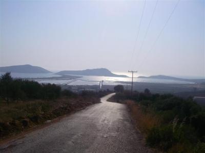
The landscape between the towns was mostly olive groves and scrubby plants on rolling hills. There were a couple industrial stores and a handful of homes, but for the most part there was no development between the towns. It was a nice drive.
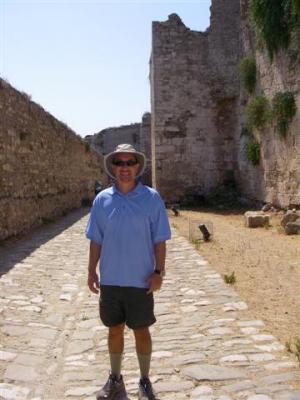
When we arrived at the castle, we saw admission was free, so we were expecting it to be a dud. We were surprised to find that it was actually quite good, with some of it very well preserved. It is much better than the castle at Kos.
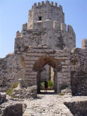
The castle was originally built by the Venetians in 1209 and expanded many times over the next 200 years. You walk in on a fancy stone bridge over a now dry moat, through a grand entrance gate. The entrance was an addition in made in 1714. When the entrance was made, there was an easily removable wooden bridge resting on pillars of stone. In the early 1800’s the permanent and decorative stone bridge was added. Once inside, there is a fairly long walkway where you have nothing but huge walls on either side of you.
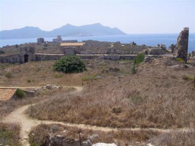
At the end of the walkway are the gates into the castle complex. When we stepped through the gate, we were taken aback at how large it is. It covers much more land mass than you realize looking at it from both sea and land. This photo does not do the size justice, nor can you tell from the photo how many buildings are left in tact. We found out later it was the largest castle in the Peloponnese. During the time of the Venetian rule, Methoni was a regular stop for Europeans going to/from the Holy Land. It was one of the main places for re-stocking supplies. Hence, the consistent enlargements.
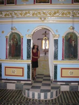
From the entrance, we decided to head south first. A few of the remains have signs, but not many. One building relatively close to the entrance was obviously a church. It was a newer looking (relatively speaking) rectangular building with a bell. Inside, it looks like it still is in use today.
There were several small little structures around, most of which we have no clue what they were once used for. They are all quite different from one another and spread quite a ways from one another in what is mostly a large, grassy field. According to a sign, the whole grassy field was once a bustling city with narrow streets and wooden houses.
We thought we had gotten to the end of the line when we got to the south wall, and were surprised to find that there is another fortress tower on a tiny island connected by a bridge. The first picture is of the entrance to the tower, the second is of the south wall and bridge from the tower.
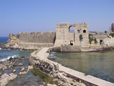
There is a courtyard around the tower. The entrance is small and low, and the staircase up is narrow, windy and dark. The tower is most impressive. The windows are tiny and the walls are a good 4 feet thick. No exaggeration. The ceiling is really tall. The sign said that there were four more stories made of wood above where we stood. This fort was built in the 1500’s.
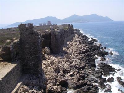
We left the tower and walked back through the south gate. We walked up along the west wall, admiring the ocean below. Here the walls are totally crumbling and falling apart, but you can still get a sense of what it must have once looked like. The ocean below is a beautiful aquamarine color, but the rocks are foreboding and ominous.
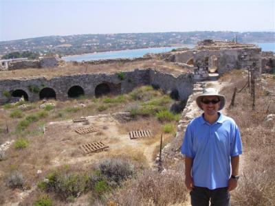
To enter the northern part of the fort, you have to go through yet another set of walls. We are guessing the walls were once the northern end of the fort and the part beyond the walls was one of the later expansions. Here is Eric standing on top of the wall with the northeast side of the castle behind him.
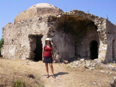
As you continue north, there is a relatively new rectangular building with a tiled roof, similar to the church minus the bell. You can see the edge of it in the second photo above. It was closed to the public. There was a fortress wall not too far behind it. It is an inner wall, but there was no reason to think there was anything of interest between the inner and outer wall. It seemed we were at the end of the line. But, as we wandered around the grassy field close to the building a little more, we came to a small, non-descript descending flight of steps. It sort of looked like it led to nowhere and wasn’t worth going down. It turns out that these steps were the entrance to another vast, multi-story set of buildings. This area has that mystic “castle” feel. There are many little nooks, crannies and passageways. The buildings have that weird multi-layered building on top of building effect where you can’t tell where one ends and another begins. There are actually tunnels that run through the outermost fortress walls where soldiers would man canons sticking out of holes within the walls. There are little alcoves in the opposite side of the walls, which we assume was for canon ball storage. The area was large and extensive. It was definitely the most intriguing part of the entire castle complex.
After leaving the castle, we headed north past Pylos to Gialova. According to the map there were several sites clustered in one little area just outside of town. We stopped in the village for lunch. The village is adorable. We keep forgetting to mention that a popular fruit juice in Greece is sour cherry juice. It is not at all sour, though slightly tart, and tastes like cherry Juicy Juice. This restaurant serves banana-cherry juice and it was phenomenally good.
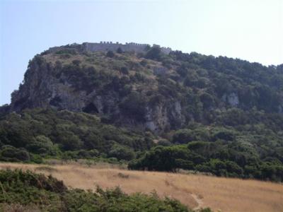
After lunch we followed the coast around to a man made bay that is now a bird sanctuary. You can drive along the southern side of the bay, along a narrow strip of land separating the ocean and bay. We followed the road to the end. There were tons of people on the beach of the ocean side. It was packed. At the end of the road, the land becomes hilly and makes a sharp right hand turn. On the hill directly ahead are the remains of another castle/fort. There were two signs posted, one saying the castle is closed to the public and another pointing to Nestor’s Cave. We think Nestor is the mythological king of the area and this cave is somehow significant in his story, but we are not too clear on the story itself. We followed the dirt trail north along the east side of the bird sanctuary bay.

The trail eventually split from the bay, and the soil went from hard packed dirt to sand. The trail became hard to follow and seemed like it might have split a couple times. It also went from flat to hilly. There was absolutely no sign of a cave anywhere, nor any other signs confirming we were still on the right trail. We eventually came to yet another bay, this one natural looking, also packed with sun worshippers. Here is the photo of the bay we were at in the foreground and the bird sanctuary bay behind it.
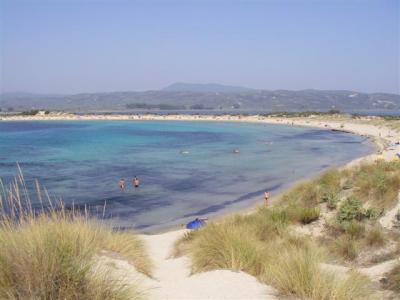
Still totally bewildered about the cave, we turned around and southwest, climbing up a fairly small hill beyond where the bay ends to look at the ocean beneath. From the top of the hill, not only did we have a beautiful view of the sea, we also had a nice view of the fort above us and the cave inside the mountain the fort stands on. Ah ha! It was hot and sand hills are a pain to climb up, so we decided we didn’t want to go to the cave because it would be way too much work. We headed back to the scooter and moved on to the next site. Oddly enough, we did not see or hear a single bird either time we walked along the edge of the bird sanctuary. Weird.
The next site we went to see was the Kalamari Waterfall. Of course, it hasn’t rained in months, so we knew chances were it was dry. When we were close, we found a handmade sign that said “waterfail” pointing down a small road. It led down to a valley and dead ended into a farm. Hmmm. We went up and down every side street between the sign and the dead end and didn’t see anything that even remotely resembled a waterfall. In roaming the streets, we found a traditional small village where we got lots of curious stares as we roared around. The village has a definite rural quality to it. Many people had land around their homes with crops and animals. There were more than a few chicken and goats.
Our last effort at sightseeing was to go to a monastery near this village. We didn’t want to go in, but it was supposed to have a beautiful view from the parking lot. We felt kind of bad roaring in on the scooter, shooting a couple photos and leaving. We got a lot of stares from the monks inside.
We could have also gone to the fort in Pylos, but at this point we were tired ready to call it a day.
[232]
wow that sounds like a truly awesome day. That might be the coolest castle i’ve ever seen!