
Yesterday we had rented the car at 0800, but the car wasn’t actually due back until 1300 today. Nice! We decided to make the most of our time and took a drive over to the northeast corner of the island, the only major area we haven’t explored yet. The map shows a paved road that went due east to the coast. There is a connecting dirt road that follows the coast around to the north of the island that meets up with the main highway near Rincon. There are four caves up there with Indian inscriptions that sound interesting to see.
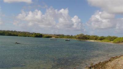
The road east is one we haven’t been on before. It is pretty much residential the whole way. We drove to the wetlands that open into the ocean and stopped. Hmmm”¦ the road north should be right here somewhere. It is a scenic location and we took some photos before getting back in the car.

On the next pass we saw the road. It had a sign for a ranch that made it look more like a driveway than a road, which is why we missed it in the first place. At first the road was fine. It was a little rutted out from when people drove in the mud, but it was a clearly marked road and it looked like it was regularly maintained. The farther north we went, the thinner the vegetation got. The trees slowly disappeared, replaced with low growing scrubby brush. The big bushes became fewer in between. It was really starting to look like the desert island it is supposed to be. Even the cactus plants thinned out. We passed what we presume was once the advertised ranch. It has been a long, long, long time since it was in business. There is a dilapidated shell of a building and not much more.
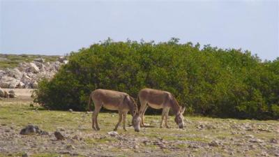
There were a lot of donkeys roaming around, clearly wild animals grazing. Invariably, every one of them would watch us intently as we drove by. They were obviously curious about us. There seemed to be a certain “safe” distance in their minds. So, if they were far from us, they would move in closer, and if they were close, they would move out farther to get to the right viewing distance.
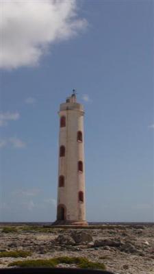
By the time we got to the lighthouse at the northeast tip of the island, the road was faint and it almost looked like people were driving where ever they wanted instead of sticking to a set road. Up here even the scrubby brush is thin, so there are no real obstacles to driving in the dirt. The shoreline is a coral shelf, probably only about three feet above sea level, but a distinct wall, not a gradual slope. We were surprised by how violently the waves were crashing against the shore. There were a lot of tall waves shooting up into the air. Next to the lighthouse is another building that has been long abandoned. From how well the building has managed to hold together, it looks like it was once a high end building.
From here the road turns west. There were four Indian caves on the map and they looked like they were all pretty close to the lighthouse. For some reason, we thought they would be clearly marked. We looked carefully for signs, but never saw any. We were growing more and more uncomfortable with the road. It was kind of vanishing. It looked to us like instead of actually clearing a road, naturally nothing grew on this little stretch. It was really desolate out here, with very little plant life. The one thing that gave us hope that this was a real road was that there were some rocks piled off to the side, indicating that someone had made an effort to clear it.
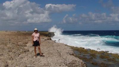
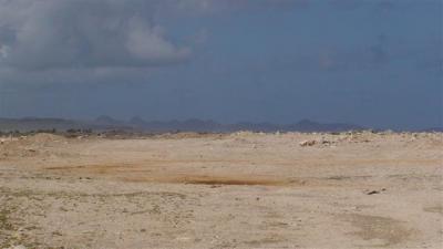
Then the road dissolved into nothing. We were literally off roading now, veering around bushes and splashing through low points in the ground where ocean water was pooling. It is a good thing we rented another 4 wheel drive vehicle. While our little Suzuki had no power, at least it had the right kind of tires and suspensions for an off road adventure. By this point, we had gone too far to turn back around. It seemed like it couldn’t be much farther until we would hit the highway. We’d just keep 4 wheeling. You can see it is pretty flat and arid where we are, and in the distance are the hills of Washington-Slaagbai park.
Then we saw a dirt road in the distance. Phew. We headed over to it. It ran back south. Hmmm”¦ the highway is east. We decided to follow it, figuring it had to go somewhere. It took us to the base of some hills. The hills here are sheer cliffs. This looks like a likely spot for caves to be hiding. The road turned and headed back west. We followed it for a little while, stopping a few times at places that looked like they had cave potential. But it was clear there are no signs, and we have learned from experience that caves are hard to find if you don’t know exactly where to look, so we gave up and turned back around.
Our instincts that we were close to the paved road were actually right on. We only off roaded for a few more minutes before we finally came to another dirt road. We suspect that the road at the lighthouse once connected all the way through to this road, but with all the violent waves the road washed out and is just too much effort to maintain. The dirt road only went a few miles before it put us back on the main road, right near the land sail place. When we saw the land sail vehicles in the distance, we were overcome with relief. Phew. We weren’t lost. We didn’t run out of gas in the middle of a desert where no one would ever find us. All is good with the world.
Believe it or not, we actually returned the car on time. It was caked with dirt. When we had left this morning, we were still feeling a little beat up from yesterday’s activities, and now we were feeling worn out from the hours of bouncing, so we had a low key afternoon. In the evening, our neighbors on Nereia had us over for dinner, along with the other couple we had met in Washington-Slaagbai. It was really fun.
Many people ask us what we consider to be “flaws” with the design of our boat. We don’t view this as a flaw, but others may, so we are going to mention it. Our boat is not a good party boat. It seems that most other boats have roomy cockpits with tables and seating for 6 to 20 people, depending on the layout. Guests can drop by unexpectedly and hang out in the cockpit without ever having to go inside. We are rarely invited inside other people’s boats. Our cockpit is tiny. We can fit three folding chairs back there, which doesn’t work when we invite another couple over. So, when people stop by our boat, we invariably bring them inside. Inside isn’t much better. We eliminated the port settee, so we can only seat 4 at our L-shaped table. The seating is awkward, making it difficult to talk to one another. Every boat has its trade offs, and since we don’t do a lot of entertaining, we don’t mind not having a party boat. But for those that do like to entertain, it could be an issue.
In frustrating news, Christi lost her cell phone. She can’t imagine where on earth it could have possibly gone. We went back to every place she might have dropped it, all to no avail. She contacted her carrier, AT&T, to see if anyone was using the phone. AT&T immediately shut off all service. They told her she could not restore service unless she purchased another phone directly from AT&T with a two year service contract attached to it. Oh, and they won’t ship a phone out of the country, so she just can’t have any service since they can’t get a phone to her. Period. Turning voicemail on so at least she can check messages is not an option either. Oh, and since she is still on a monthly contract with them, she still has to pay each month for no service. She is so mad at AT&T.
I think everyone understands Christi’s cell phone pain. Sometimes paying the early termination fee is worth it.
Wish the events you posted about hadn’t happened months ago; my input might otherwise be worthwhile. But in case it ever happens again, you should know that AT&T has a secret “0 minutes/$0” monthly plan that you can switch to at any time. You’re still on contract so your number is locked up and you can’t get a new phone from them, but you won’t have to pay any monthly fee through the end of your contract. And voice mail will still work (I think). The only helpful AT&T employee I ever met told me about it. YMMV, of course.
/afb