
After days of debate, we finally decided to take a group tour to Santorini rather than take Kosmos. Santorini does have a first-come-first-serve marina, but there are not any good anchorages, so if the marina was full, we’d have to anchor in deep, rocky water. If we anchored, we would worry all day about Kosmos drifting or the anchor getting stuck in rocks, which would take the fun out of the trip.
The tour bus picked us up at 0700 and took us to the ferry in Irakelo. We made a zillion stops along the way to pick up additional passengers, so we got to the ferry around 0900. The ferry is a huge catamaran, we are guessing 100 meters long (300 feet). We estimated 500 people to be on board. The ride took 2 hours. In Kosmos, it would have taken 14 hours. It was the smoothest boat ride we have ever been on; so smooth that we didn’t even realize when we’d pulled out of port.
We already mentioned in the History of Greece post that the island of Santorini was part of the powerful Minoan civilization based on Crete. The Minoans named the island Strongili, which meant round. Around 1650 BC, a colossal volcano eruption caused the middle of the island to sink under the water, creating one of the largest calderas in the world. The ancient Minoan town of Akroitiri was discovered in 1967, buried intact by the volcano. As a side note, many believe that the sinking of part of Strongili is the basis for the myth of the lost city of Atlantis.
The island was renamed Thira by subsequent Greek colonizers. Thira was one of the islands the Venetians gained control of in the 1204 attack on the Byzantines. When the Venetians took over, they renamed the island “Santa Irini”, which is Saint Irene in English. Over the years, the name evolved into Santorini. When Greece became an independent nation, they changed the name back to Thira. Even though it is not officially named Santorini anymore, the name has stuck and is still the commonly used name for the island.
The 1650 BC eruption completely changed the shape of the island. Since then, there have been numerous volcano eruptions and earthquakes that have continued to re-shape the area. Today, Santorini is now sort of a lopsided crescent shape. Along the caldera side of the island are dramatic, sheer vertical cliffs. There are five islands in the bay created by the caldera. Some are mountain peaks from the sunken ground that stuck out above the water, a couple were newer additions from subsequent volcano eruptions. One of these islands is home to the volcano. The volcano is active, giving off heat and gasses, but no lava. Geologists believe it is not hot enough to erupt again any time soon.
Our ferry brought us in on the caldera side of the island. From the distance, Santorini and its surrounding islands look like Lake Powell with a sprinkling of snow. By that we mean sheer, vertical cliffs rising up 600- 900 feet out of the water, with an interesting geological pattern on the rock face. Of course, the soil in Santorini is volcanic and dark and in Lake Powell the soil is redish. The top of the cliffs are flat, and the “snow” is the buildings at the top of the cliffs, which are mostly white. This contrasts sharply with Crete, which has tall mountains rising to pointed peaks, with buildings nestled along the mountainside.
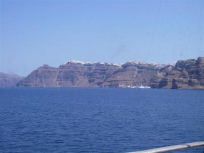
We had to wait a few minutes in the bay before we could pull up to the ferry terminal, because another enormous ferry was unloading. We watched bus after bus fill up and take off up the switchback road cut into the cliff. When we pulled up to the landing, we were directed to a slew of waiting busses. Each bus was marked with a language, and you got on the bus of whatever language you spoke. Oddly, there was no Greek bus, which we though was weird. There were quite a few Greeks on board. There were at least 6 busses for our ferry, maybe more.
We headed up the mountain. As soon as we got to the flat land at the top, the earth was dominated by a crop that was low, round and leafy. It turns out they are grapes. Rather than grow the vines on poles like you normally see, here they weave the vines into a basket shape. Keeping it low protects the fruit from the wind, and the shape keeps the leaves over the grapes, protecting it from sun scorch and dust. Wine is Santorini’s biggest industry behind tourism. Their dessert wine has apparently won a lot of international awards. In addition to grapes, they also grow cherry tomatoes and pistachio nuts. Interestingly enough, the land is not irrigated. Despite the fact that it only really rains in the winter, the ground and air have enough moisture to sustain the plants without any additional water.
The bus stopped at a nearby village located in the middle of the island, which we think is called Pirgos, but we aren’t sure. The busses from the other group were already there. We got out and joined the sea of people on the narrow walkway leading to the top of the hill. We only had 40 minutes in this town. Progress up the hill was painfully slow. It was just too narrow to push your way through any faster”¦ you were stuck at the pace of the group, which is set by the slowest walkers.
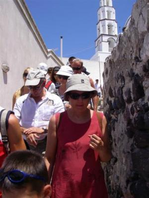
This village is the most odd we have seen in terms of construction. The buildings all kind of blend together into a weird maze of twists and turns. It is often hard to tell where one building ends and the next begins. For example, many of the rooftops of one building seem to be the first floor of another building higher up the hill. Doors and windows are in odd places, seeming to lead to nowhere. Every available inch of space seems to have been utilized in some unique way. The combination of the narrow roads and being pushed along by the wave of people made it difficult to take photos.
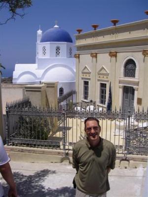
We are not sure how old the settlement is, but we are guessing pretty darn old. We saw a Venetian building. We also read in Lonely Planet that during the days of the Ottoman Empire the Cyclades Islands were prone to pirates invading and attacking the islands. The towns were constructed as high up as possible and the labyrinth of narrow, maze like streets was deliberately designed to disorient the invaders. The bizarre architecture just adds to the character and charm of the town. Most of the buildings are white, many with royal blue trim. There are a lot of churches in this little town, one church for every 5 families. Almost all of them have a dome painted royal blue. Here is the Venetian building with one of the famous blue domed churches.
As we marched along like ants in a line, we thought about… To be continued…
Just had the best note from Sonny! She sounds terrific, which is so heartening. I’d sent her card, and was delighted that she replied. Hurray!
Just sending a big HELLO! So glad you are keeping this up to date so I can figure out where you have been! Take care and travel safe.