Dana Point Nordhavn Dock Party Tuesday, May 26

Once again we interrupt blog time with a real time announcement. We will be in Dana Point on Tuesday, May 26 to celebrate our circumnavigation with the staff of Nordhavn. They will be having a dock party at 4pm. If you can make it, send us an e-mail. Address and directions: 24703 Dana Drive, Dana Point, CA 92629, directions.

Alas it will not be an open house to see Kosmos, but it will be a chance to see us and a bunch of the Nordhavn folks that made our trip possible. We hope to see you there!

The Mangazina di Rei

Continued from yesterday”¦ After we finished at the museum, we headed to Rincon to go to the Mangazina di Rei cultural center. It is housed in the second oldest stone building on the island, built in 1824, which was originally built as a food and farm tool storage center. The center tries to actively preserve the cultures and traditions of 100 years ago. We expected it to be a museum where you wander around at your own pace, but it was actually a guided tour. We joined a tour group about halfway through the tour. The group had just gone out into the gardens.

In the gardens, they grow the plants that were used for every day living, from food to export crops to materials for tools. They pointed out a tamarind tree, then gave us some tamarind juice to taste. It tastes kind of like beans and sugar and is different. They pointed out a calabash tree. Calabash are inedible, hard, and round, and are good for making assorted tools and cookware, such as bowls, ladles, and so forth. The musical instrument maracas (the shakers popular in Latin American music) are made from calabash, too.

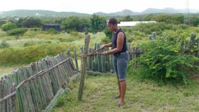
They showed us candle cactus, which are used to make the living cactus fences. For some reason, they can only be cut on a full moon in the dry season or they rot. The guide showed us the tools they used to cut, move, and replant the cactus along the fence. The cactus cuttings form new roots and become a living fence.

dsc02259-small.jpg

The guide also pointed out the kadushi cactus that they make a traditional soup from, and also explained how they cut and skin the cactus to get at the pulp inside. The cactus is absolutely enormous, but only young shoots are eaten.

They showed us the plants that sorghum flour is made from, which was the staple of the traditional diet. Sorghum is Continue reading

Washington-Slagbaai Park

This morning we awoke to partly cloudy skies, but no rain. We had to bail a ton of water out of the dinghy and there were big pools of water in the street, which we took as a bad sign for the long road to be open. We hopped in the jeep and headed back up to the Washington-Slagbaai park.

This time we took the coastal road up. When we had gone to the camera store on the edge of town the other day, for some reason we thought there wasn’t much development beyond that point. We turned out to be wrong. Just around a bend in the road, out of the line of sight from where we were standing that day, is where the Continue reading

Exploring Southern Bonaire and Windsurfing Lessons

Continued from yesterday”¦ Near where the wetlands turned into Luc Bay, the salt pans started. Almost all of the south side of the island is owned by the salt company, and there are miles upon miles of salt drying “pans”, which are large, shallow troughs of water dug into the ground. As we drove south, we found ourselves on a narrow strip of land. To our left was the ocean and to our right were the pans.

There were quite a few flamingos grazing in the salt pans, all out in the distance, of course. The flamingos feed on brine shrimp, crustaceans, plankton and algae, which are all easily accessible in the shallow pools. We know that deeper in the salt flats is a flamingo sanctuary, one of the four main breeding sites for the entire Caribbean flamingo population. There is no road to get there, it is strictly off limits to the public, and it is too far from the road for people to see them. It sounds like the flamingos here regularly fly back and forth from Venezuela.

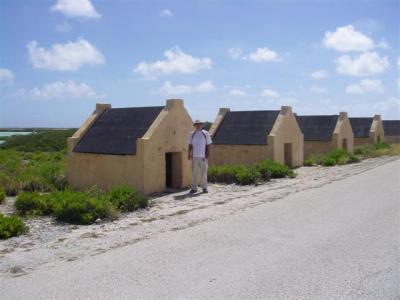
On the windward side of the ocean there were huge waves pounding the shore. We passed a lighthouse at the southernmost point of the island. As we came around the bottom of the island towards the leeward side, we saw the infamous slave huts. They are situated just at the edge of where the surf dies down, close to the lighthouse. Beyond the huts, on the ocean, there were some kite boarders skimming along the water, just like the day we arrived on Kosmos. It is really quite scenic.

The huts are almost shocking. They were built in the 1850’s, and were apparently an upgrade from the mud huts that were used prior. Several people were crowded into these shelters. As you can see, they are tiny — barely long, wide and tall enough for someone short to stand up/lay down in. Putting two people in one of those would be “cozy”, particularly if one of them was tall, and apparently many people were crowded into each of them.
imgp9718-small.jpg

The salt mining work was hard — slaves used wheelbarrows, shovels and picks to mine the salt in the burning sun. Ships picking up the salt would anchor off the coast. The slaves would load basketfuls of salt into dinghies and deliver the salt to the ships.

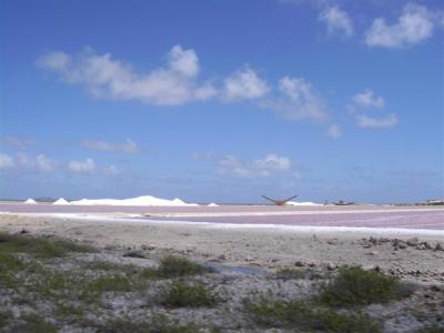
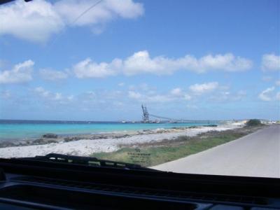
As the road continued north, the salt pans changed in color from clear to purple. It is kind of surreal to see purple pools of salt, but cool looking none-the-less. We passed numerous trucks pulled over on the side of the road, clearly divers who are doing shore entries. We passed mountains of (white) salt piled up near an interesting looking, roller coasteresqe contraption that moves salt to a dock where ships can tie up. It amazes us that the mountains haven’t melted away in all the rain.
imgp9732-small.jpg

imgp9731-small.jpg

The mountains and contraption must mark the Continue reading

Exploring Bonaire

The forecast for both today and tomorrow said sunny with no rain. Thank goodness. We have postponed exploring the island because it has been raining so hard every day. So, this morning we headed to shore early. It was drizzling lightly and quite gray, so we were dubious about the forecast’s accuracy.

We found a car rental place and rented a 4 wheel drive Jeep. The plan was to go up to Washington-Slagbaai National Park. They only allow vehicles with high wheel clearance in the park, and 4 wheel drive is recommended in the wet season. The lady who rented us the car explained that there were two roads through the park, the long road along the coast and the short road inland, and said the long road is much more beautiful than the short road. There are supposed to be some nice spots to snorkel/dive off both roads. By the time the car paperwork was completed, the drizzle had burned off and it was sunny and gorgeous out.

We drove east a couple of blocks and quickly found Continue reading