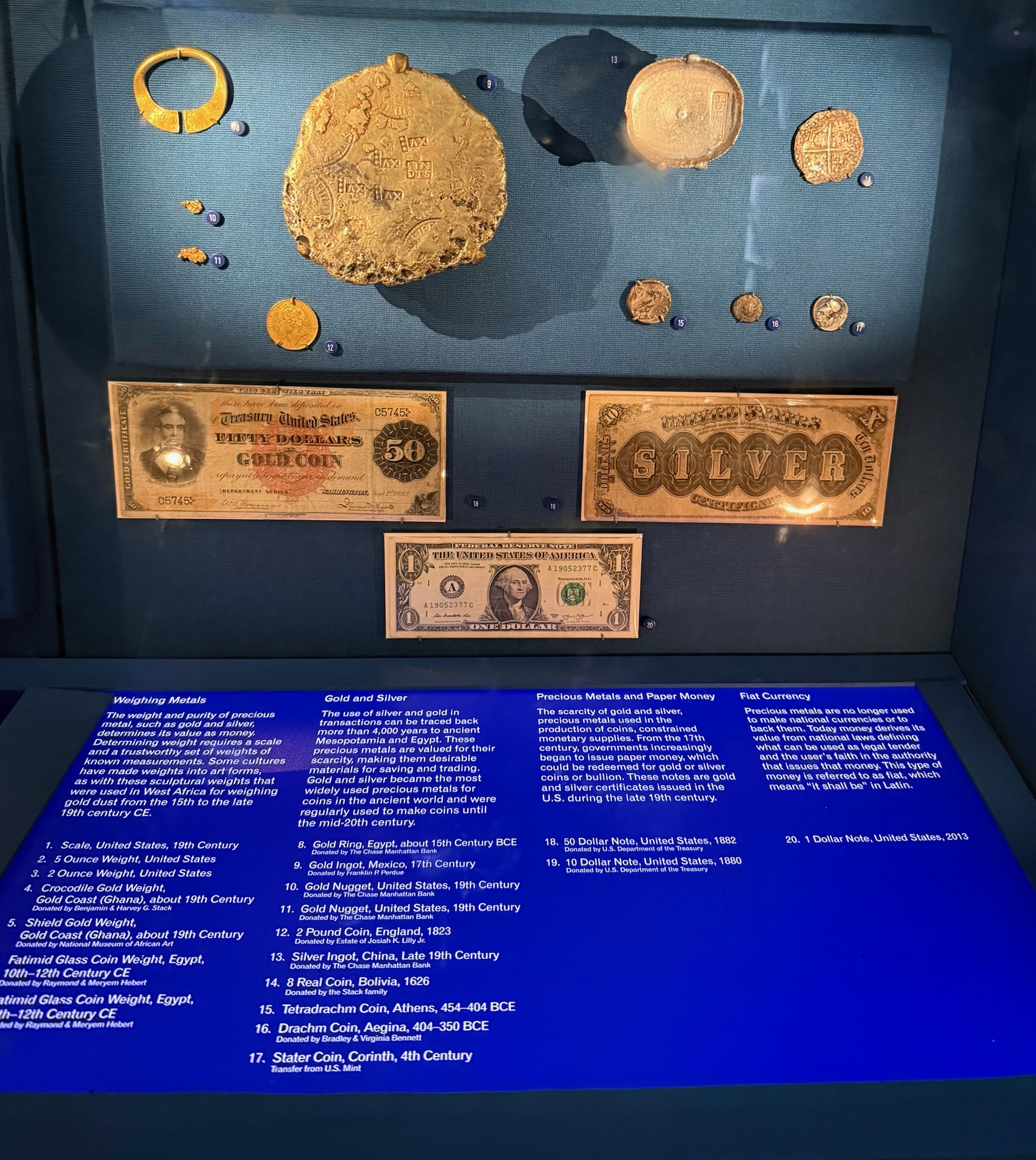
Carti Suitupo and the Kuna Cultural Museum

Today was the busiest day we have had in a while. Since we went to bed early, we were up early, too. We peered outside. No cruise ship. We made breakfast and again peered outside. This time we saw the cruise ship in the distance, approaching us. We decided to get to shore ASAP. We knew it would take the cruise ship a while to bring down their tenders and shuttle the tourists to shore, so maybe we could get in and out before too many tourists flooded the islands.

We quickly got the dinghy down and headed out to the closest island, Carti Suitupo. Carti Suitupo is the closest to the mainland of all the islands, and thus the most densely populated. We went there first because it is the island with the museum. We saw a dock just around the corner from Kosmos’ line of sight, a small wooden dinghy dock. We watched a motorized dugout canoe with two tourists pull up to the dock. We pulled in on the other side of the dock and waited until a local wandered by, then asked if we could leave our dinghy there. He said no problem.

From the dock there was a narrow dirt walking path that led between tightly packed huts. Most of the huts had bamboo walls and a roof made of thick layers of palm fronds. A few of the huts had a slanted metal roof similar to what we saw around the rest of the Caribbean. We did see a couple of buildings made of concrete. Some of the huts were almost touching. All the yards were surrounded by bamboo fences. The edges of the houses and the fence were literally on the edge of the walkway. With the housing so tight, in a way, it reminds us of Medieval European cities, except in Europe the buildings aren’t made of bamboo and palm fronds.

imgp9982-small.jpg

There were a lot of people walking around, many carrying big quantities of assorted food products. Several times we had to Continue reading

Welcome to the San Blas Islands, Panama

At around 0330, we approached the east end of the San Blas archipelago. We were heading for the Canal Caobo, a channel just south of the group of small islands known as Holandes Cays. Eric slowed down to 1400 RPM. He set the radar/chart plotter so that the charts overlaid on top of the radar. He studied it carefully to make sure the land masses matched the chart exactly. He made sure the depth we matched the chart. We were relieved everything lined up. We proceeded slowly into the channel, carefully watching the depth sounder to make sure the depths continued to match the charts. This is the first time we have ever done a night entry without navigational aids, such as channel markers. Flying blind and relying on your electronics is a little scary. By a few minutes before 0600, we were as deep as we dared to go in the dark. We had hoped the sun would be rising by then, but it was still pitch black.

It was relatively calm in the channel — for the most part, at least. We did get the occasional bigger wave. It was a million times better than Continue reading

History of the Kuna, An Indigenous People Group of Panama

Lake Madden is a man-made lake in Panama that is part of the Panama Canal system. Evidence has been found in the Lake Madden area that indicates humans first settled there 11,000 years ago. It is believed the people flourished since it was so full of natural resources. The word Panama is derived from an indigenous word meaning “an abundance of fish”. Evidence shows that some of the first pottery making in the Americas started in Panama at around 2,500 BC. It is believed agricultural activity in Panama started as far back as 3,500 years ago. Around 100 BC an extensive trading network that reached from Peru up to Mexico was established and Panama was part of it.

In 1501, the Spanish explorer Rodrigo de Bastidas “discovered” Panama. At the time, the Kuna people were Continue reading

Diving Class Bottom

We again talked Jack and Mike into taking us diving. This time we headed north to a wreck dive we had heard about. The wreck is in front of a dive center, and there was no mooring to tie to. We asked the dive center if we could tie up to their pier. They told us it isn’t a very good dive and suggested we go to a better wreck dive down south. Apparently, it was just a small wooden boat that is almost totally disintegrated now.

We motored over to the exact spot that the dive guy said the wreck was located and Jack stuck his face in the water. He agreed it wasn’t worth exploring. Since we were already up north, we decided to go to a nearby site that sounded especially nice. It is called Class Bottom. We tied up to the buoy. There were a lot of fish right under dinghy, especially sergeant fish and the little gray chromium fish. A good sign indeed!

Jack snorkeled around the general area, but once again, said it really wasn’t a very good snorkeling spot. Mike, Christi and Eric dove it and thought it was a great dive site. After we jumped in, we headed south to the next dive site marker, called Andrea I. The visibility here is the worst of all the sites we have been to in Bonaire, but it is still good. The visibility everywhere else has been phenomenal. There is very little trash around, and we expected a site farther away from town to be more pristine.

Once again, Mike brought his camera, so we can show you some of the fish we saw. The first is called a black margate. The second is called a jolthead porgy. The third is called a schoolmaster. The schoolmaster is in a giant sea rod soft coral. The three mounds in the foreground (left, right, middle) are great star hard coral, which Christi thinks looks like cells.

black-margate-small.jpg

jolthead-porgy-small.jpg

schoolmaster-giant-sea-rod-soft-coral-small.jpg

This spot has the best Continue reading

The Mangazina di Rei

Continued from yesterday”¦ After we finished at the museum, we headed to Rincon to go to the Mangazina di Rei cultural center. It is housed in the second oldest stone building on the island, built in 1824, which was originally built as a food and farm tool storage center. The center tries to actively preserve the cultures and traditions of 100 years ago. We expected it to be a museum where you wander around at your own pace, but it was actually a guided tour. We joined a tour group about halfway through the tour. The group had just gone out into the gardens.

In the gardens, they grow the plants that were used for every day living, from food to export crops to materials for tools. They pointed out a tamarind tree, then gave us some tamarind juice to taste. It tastes kind of like beans and sugar and is different. They pointed out a calabash tree. Calabash are inedible, hard, and round, and are good for making assorted tools and cookware, such as bowls, ladles, and so forth. The musical instrument maracas (the shakers popular in Latin American music) are made from calabash, too.

They showed us candle cactus, which are used to make the living cactus fences. For some reason, they can only be cut on a full moon in the dry season or they rot. The guide showed us the tools they used to cut, move, and replant the cactus along the fence. The cactus cuttings form new roots and become a living fence.

dsc02259-small.jpg

The guide also pointed out the kadushi cactus that they make a traditional soup from, and also explained how they cut and skin the cactus to get at the pulp inside. The cactus is absolutely enormous, but only young shoots are eaten.

They showed us the plants that sorghum flour is made from, which was the staple of the traditional diet. Sorghum is Continue reading