Today we waited around for the boat measurer. Christi continued cleaning. Eric spent most of the day socializing, and Christi would join in now and again during cleaning breaks. At 1400, Victor told us if the measurer hadn’t come by now, he wasn’t coming today. Good, at least we could do something fun this afternoon.
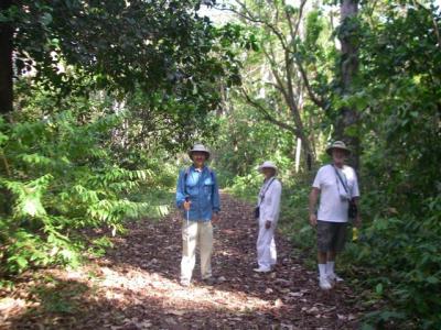
At 1530, we went for a walk in the jungle surrounding the marina with Tom and Susan on the Nordhavn 40 from San Diego. Tom and Susan explained that the marina is situated in what used to be an American Navy base, Fort Sherman. The base was constructed in 1911 to protect the unfinished canal. It was abandoned in December 1999 along with all the other American military bases in Panama. The majority of the land that the base encompassed is undeveloped jungle, and it is was one of the primary military training centers for jungle combat training, particularly during the Vietnam era. When the Panamanians took over the land, they turned it into a nature preserve. Tom and Susan walk through the preserve often, and have sometimes seen Panamanian troops doing training exercises in the preserve.
We followed a walking trail behind the marina into the jungle. The trail runs up a gently sloping hill. The path is obviously frequently used, but it doesn’t look like anyone formally maintains it. On both sides of the path the plants tall, thick and dense.
As we were walking along, we were mesmerized by the giant leaf cutter ants. There are zillions of them marching in perfect lines around the trail, most carrying big pieces of leaves much larger than they are. These ants are actually farmers. They cultivate a Continue reading